For appraisers, lawyers, insurers and municipalities

What changed at this address? Satellite evidence you can check.

Give us an address and an event date. You get a PDF report that measures radar change against that place’s own normal, shows the sharpest before-and-after images we can find, and lists every scene, licence and file hash behind the result.

  • Radar sees through cloud and at night
  • Baseline: the same place, a year earlier
  • SHA-256 hash for every figure

Every report is a screening indicator that requires expert review. It is not proof of damage, a valuation, or a legal or engineering opinion.

Orakta Screening report · sample

Screening report

Kahramanmaraş city centre, Türkiye

Event 6 February 2023 · after-period 7 February – 8 April 2023

Requires expert review Screening indicator, not proof of damage.

Above baseline

Change signal above the local baseline

Change at the pin
6.93 maximum within 30 m
Local control threshold
4.55 99th percentile, a year earlier
Built-up area above threshold
76.8% within 300 m (60.1% of the whole area)

Evidence bundle SHA-256 ab101d74…e38d · 3 radar orbits · scene IDs and licences
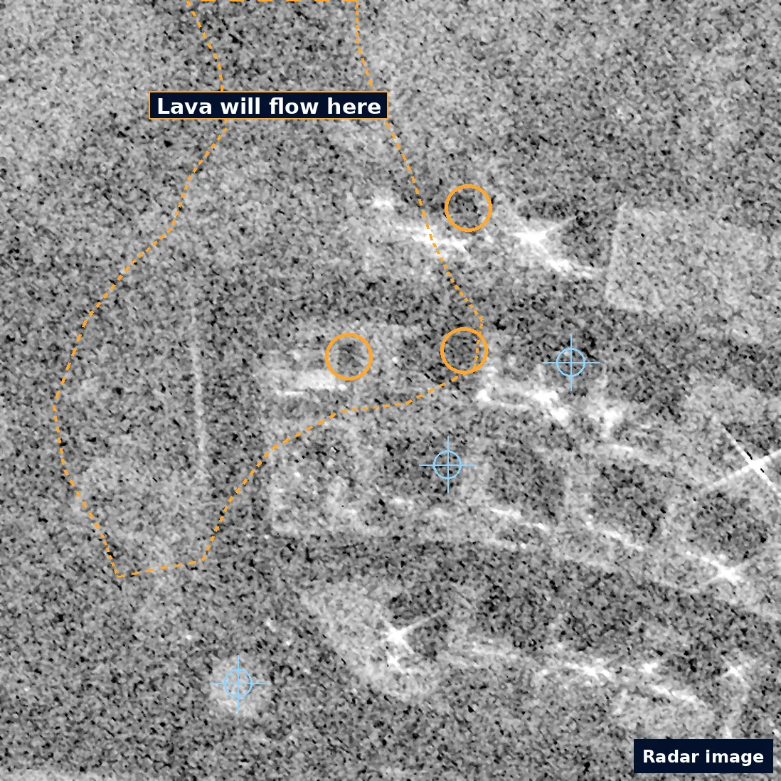
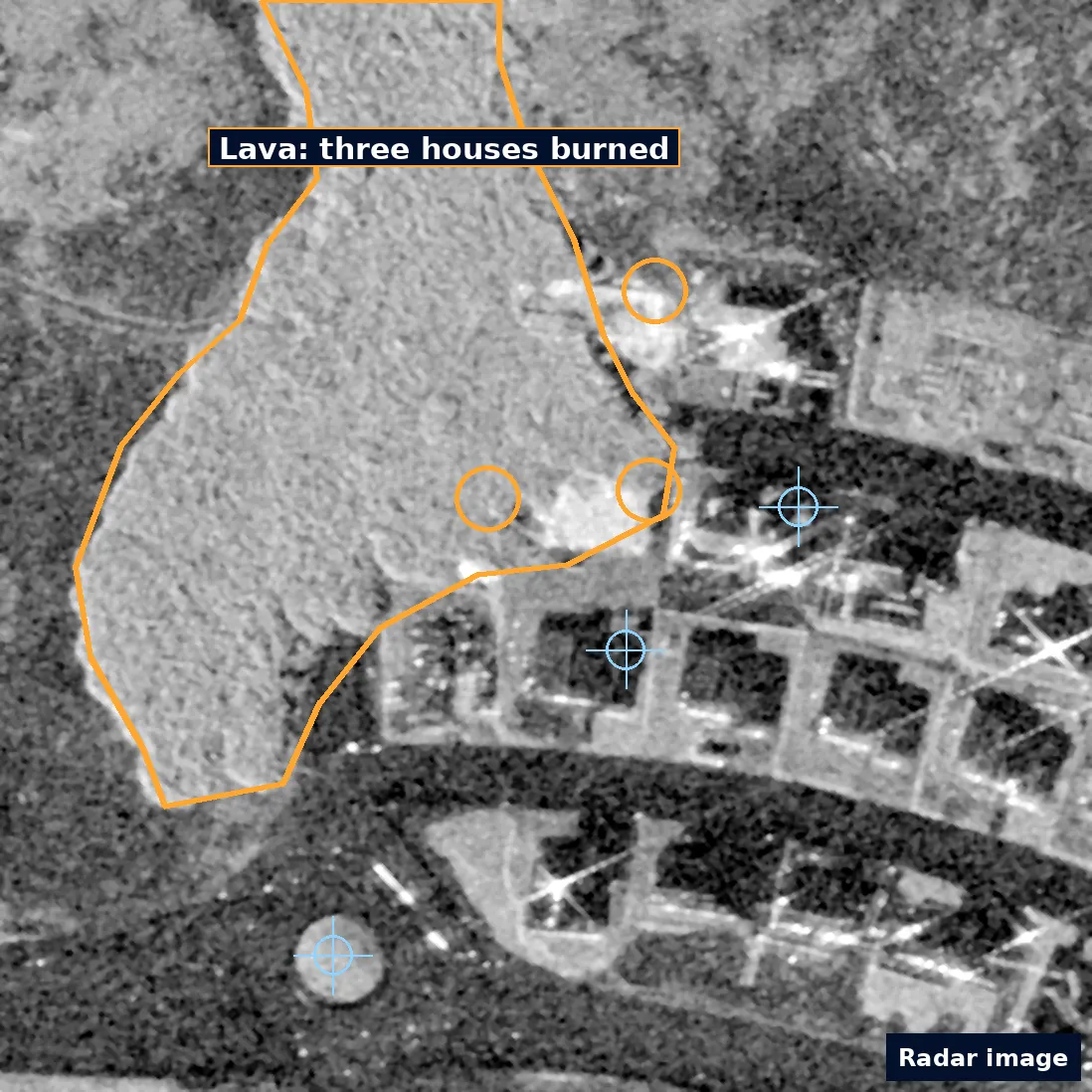
Satellite radar example · Grindavík, Iceland, 2024 · not an Israeli case

Satellite radar image of the northern edge of Grindavík, Iceland, 14 November 2023: houses and streets, with the future lava edge dashed in amber and three houses circled.
Before · 14 November 2023 · 0.41 m Umbra Space, Umbra Open Data Program; cropped and marked up by Orakta · CC BY 4.0 (opens in a new tab)
The same area on 15 January 2024: a lava field, outlined in amber, covers the edge of the district; the three circled houses are inside it.
After · 15 January 2024 · 0.43 m Umbra Space, Umbra Open Data Program; cropped and marked up by Orakta · CC BY 4.0 (opens in a new tab)

Satellite radar images, not photos. Amber: the lava edge (dashed before, solid after) and the three houses it burned on 14 January 2024. Blue crosses mark the same unchanged points in both images. The before image is grainier.

Built on open data and a peer-reviewed method

Listed as sources. Orakta is independent and not affiliated with these providers.

How it works

From an address to a checkable record.

  1. Send the addresses

    Up to 3 addresses and the event date, by form or email. We confirm the exact building with you on a map before anything runs.

  2. Free imagery check

    The same business day, we tell you whether sharp satellite imagery exists before and after the date. Radar from the twelve months before is compared with the weeks after, so the date must be at least 12 days in the past.

  3. Get the record

    A PDF report with a plain-language result, imagery and limits, plus a JSON evidence bundle with scene IDs, capture dates, licences and SHA-256 hashes of every figure.

What you get

A report a reviewer can check, line by line.

Shown here from the Kahramanmaraş accuracy-validation run, not a mock-up.

  • A result in one sentence

    “Change signal above the local baseline.” Then the numbers: change at the pin 6.93 against a local threshold of 4.55.

  • A baseline from the same place

    The threshold comes from the same months a year earlier at that location, so normal seasonal and urban change is accounted for.

  • The sharpest images available

    Open imagery found for the place and date, each with its source, capture date, resolution and licence.

  • Provenance you can verify

    Scene IDs, capture dates, licences and a SHA-256 hash per figure (pwtt.png, for example, starts ab101d746805).

  • Method and limits on the page

    What was measured, what it cannot show, and what else can look like damage, written into the report itself.

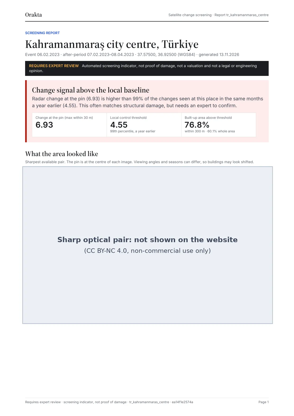
Page 1 of the real sample PDF: place and dates, the requires expert review strip, the result with three numbers; the sharp optical pair is masked on the website.
Page 1 of the sample report. The sharp optical pair (CC BY-NC 4.0, non-commercial use only) is not shown on the website.

Use cases

For teams that have to answer “what changed here?”

  • Orakta Damage Evidence, in development

    Insurance and loss claims

    “Did something change at this property around the reported date?”

  • Orakta Damage Assessment, in development

    Shelter and damage assessment

    “Is there a sign of change at this location, and is it worth a field visit?”

  • Legal and claims counsel

    “What does the satellite record show for this place and period, and can it be traced?”

Straight answers

The first questions professionals ask.

Is a report proof of damage?
No, and it says so on every page. It is a screening indicator for an expert: it tells you whether a place changed more than its own normal, and shows the evidence.
Ten-metre radar pixels: is that too coarse?
For counting cracked walls, yes. For “did this block change after the event?”, it is the right tool, and sharp imagery is added wherever an open archive covers the place.
What if it was cloudy?
The measurement uses radar, which sees through cloud and at night. Only the optical pictures need a clear sky, and the report says when they are missing.
Can the other side check it?
Yes. Every scene ID, capture date, licence and file hash is listed, so a reviewer can fetch the same public data and confirm nothing was swapped or edited.

Getting started

Start with up to 3 of your own addresses.

Send up to three addresses for a free imagery check. If sharp satellite imagery exists, a Standard report is the next step. Nothing that costs money is bought without your written agreement to an exact amount.

  • Free imagery check

    Anyone deciding whether a report can help

    Free

    Up to 3 addresses, answer the same business day

    • Whether 30 cm before-and-after satellite imagery exists for each address, its dates and the provider’s delivery time
    • If there is no imagery, you pay nothing and we tell you your honest options
    • Requests received by 14:00 Israel time are answered the same business day
    Request a free check : Free imagery check
  • Recommended next step

    Standard report

    Appraisers, lawyers and claim handlers with one building

    ₪3,900 (≈ $1,220) per building

    Each extra building in the same imagery area ₪1,900 (≈ $590). Priority handling +₪1,000.

    One building, one event: 30 cm before-and-after imagery

    • Before-and-after 30 cm imagery with the building marked, what changed, confidence and limits
    • A check of your photos (date, location, hash) and a SHA-256 evidence log kept for 7 years
    • A plain-language first page, a before/after viewer and a short narrated video
    • 3 business days after payment and the imagery order, when the provider delivers within hours; an error on our side is fixed within 1 business day or refunded in full
    Order a Standard report : Standard report

Principles

Seen and put on record.

The name joins Greek horáō, “to see”, and Latin acta, “official records”. Every report is built to be checked, not taken on trust.

  • Provenance first

    Every figure is hashed and every scene is named, so the record can be checked without trusting us.

  • Licences respected

    Each image carries its licence. Non-commercial imagery is marked and never goes into a paid report.

  • Honest limits

    Each report states what it cannot show and carries a clear “requires expert review” notice.

  • Open foundations

    Built on open Copernicus data and a peer-reviewed radar change method, with our own calibration on top.

Where we are

Early, and honest about it.

Orakta is an early-stage project built by a solo founder based in Israel. The screening pipeline works end to end on public data. There are no paying customers and no self-serve sign-up yet, and this site does not pretend otherwise. Prices are published and confirmed in a written order.

Company overview for investors and partners

Check up to 3 addresses, free.

Send the addresses and the event date. The same business day, we tell you whether sharp satellite imagery exists and what a report would cost. Nothing is bought without your written approval.